HermesTRX Indoor & Outdoor
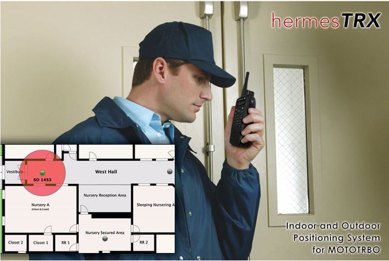
HermesTRX Indoor & Outdoor is a real-time indoor positioning and GPS fleet management system using various mapping platforms including Google Earth. It allows a dispatcher to track and manage vehicles or personnel assets by GPS-enabled MOTOTRBO radios. The maximum number of subscribers that are traceable at the same time depends on version, but is typically between 20 and 500 subscribers. It delivers an overview of the location and status of assets: outdoors using GPS, and indoor utilising hermesTRX beacons transmitting a unique ID. Indoor tracking relies on the installation of beacons throughout the various areas of a building or large complex, and fitted inside the MOTOTRBO radio is a transponder indoor option board, which also includes Man Down functionality. A dedicated floor plan upload interface allows users to display floor plans and place beacons on the dispatchers’ screen – which also includes a display of emergency situations. Configurable through a built-in web server, it is a true plug-and-play professional system, easy to set-up, also enabling users to upgrade to new features such as the hermesTRX Man Down solution, as well as the Motorola Man Down function based on the Generic Option Board.
• Indoor and outdoor positioning.
• Built-in web server for browser based operation.
• Multi-user access and remote facility.
• ARS, Telemetry, Job-Dispatching, Emergency Email, Recording and Playback.
• Voice Dispatching for multiple users.
• Geo-Fencing.
• Comes with a detailed user set-up manual and example CPS files and associated firmware.
• No monthly recurring investment costs (opex), no costs associated with software, map licences or monthly recurring fees.
• Flexible Mapping Engine, uses the most up-to-date mapping platform which is free of charge.
• Supports MOTOTRBO ‘Enhanced GPS’.
• User-friendly interface.
• A standard web browser is all that is required to set up and use the system. There are no complex drivers, databases etc to be installed.
• Flexible Mapping Engine provides the option of choosing OpenStreetMap, ESRI, Google™ Earth or any customer raster or vectorial tab format maps.
• Reverse Geocoding allows to convert GPS coordinates into street addresses.